DTED/DMED Configuration Panel (Contour Lines)
The DTED Configuration Panel allows the definition of the contour levels to be created with the DTED data. The panel is available at dataset or file level. Configuring the dataset allows the same contour levels to be applied to all of the data in the dataset.
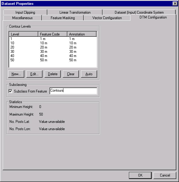
The panel is divided into 2 sections.
- The top half of the panel allows the definition of the contour lines, either automatically, or manually, and whether the feature codes for each level are subclassed from another feature name.
- The bottom half of the panel displays some information about the data. For a dataset, this will only show the minimum and maximum elevations for the files in the datasets. For a file, this will show the grid size as well.
 To automatically generate the contour line definitions
- Simply hit the Auto button. A set of levels will be generated based upon the minimum and maximum elevations.
To add a new level
- Hit the New button.
- A dialog box will appear asking for the level at which the contour should be generated in metres (for example 150), the feature code to give the level (for example "150 m"), and the annotation to use (for example "150 m" ).
- Hit OK to add the new level.
To edit an existing level
- Select the level to be edited.
- Hit the Edit button.
- A dialog box will appear displaying the current settings, which can then be modified.
- Hit OK to alter the level.
To delete a level
- Select the level to be deleted.
- Hit Delete to delete the level.
To clear all levels
- Hit the Clear button.
To subclass the features from another feature of your choice
- Enable the Subclass From Feature check box.
- Enter the parent feature name.
Copyright © 1998 to by Envitia Group PLC.