MapLink Pro Studio supports several methods of terrain sun shading:
- Aspect
- Difuse Reflection
- Combined
- Legacy Method
Aspect
Aspect is the downhill direction of slope and is derived as a by-product of the slope calculation. Aspect-based shading uses the direction of the slope relative to the sun direction, but takes no account of the sun elevation. Aspect shading is calculated according to a modified cosine shading equation (Moellering and Kimerling, 1990).
Aspect-based shading is well suited for portraying mountainous areas.
Diffuse Reflection
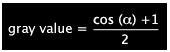
Diffuse reflection assigns each pixel a gray value proportional to the cosine of the angle between the surface normal and the light vector. Diffuse reflection more accurately depicts flatter and uneven lowlands.
Combined
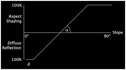
As Diffuse Reflection and Aspect-based shading both have issues, the Combined approach is to combine Diffuse Reflection and Aspect-based shading as a function of slope according to the following diagram, using minimum and maximum slope.
Setting the Light Shading:
- Sun Bearing defines the angle from North in degrees of sun position.
- Sun Elevation defines the angle from Earth of sun position. A value of zero indicates the sun is shining directly along the ground e.g. sunrise/sunset.
- Ambient Light defines background or minimum light level.
Typical values are:
- Sun bearing: 315 degrees
- Sun elevation: 45 degrees
- Ambient light: 0.3
References:
- An Interactive Approach to Analytical Relief Shading, by Bernhard Jenny, Cartographica, Volume 38, # 1&2, SPRING/SUMMER 2001.
- Hill Shading and the Reflectance Map, by Berthold K. P. Horn, Processdings of the IEEE, Vol. 69. No. 1, January 1981
Copyright © 1998 to by Envitia Group PLC.