VMAP0 is the commonly used abbreviation for the Vector Smart Map Level 0 dataset, produced by the US National Imagery and Mapping Agency (NIMA). It is an unclassified dataset providing coverage of the whole world at an approximate scale of 1:1,000,000. It is invaluable as a source of low cost, medium resolution data, and is particularly suited to providing topographic background data for a wide range of applications. It is a successor product to the Digital Chart of the World (DCW) and effectively supersedes this older dataset.
VMAP0 is implemented in Vector Product Format (VPF), which is one of the standard dataset types fully supported by MapLink Pro Studio.
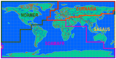
VMAP0 is provided on four CD-ROMs, covering the following geographical areas:
- EURNASIA: Europe and North Asia
- NOAMER: North America
- SAMAFR: South America and Africa
- SASAUS: South Asia and Australasia
VMAP0 can be obtained from the US Geological Survey, and is also supplied with each Development copy of MapLink Pro. Please contact sales@envitia.com in case of any questions concerning VMAP0 data supply.
Copyright © 1998 to by Envitia Group PLC.